IMD Issues Heavy Rain Warning in Tamil Nadu, ‘Yellow Alert’ for Sunday 12 January 2025
IMD Issues Heavy Rain Warning in Tamil Nadu
The India Meteorological Department (IMD) has forecasted heavy rainfall in parts of Tamil Nadu and issued a “yellow alert” for Sunday. Key districts such as Thanjavur, Tiruvarur, Nagapattinam, Mayiladuthurai, Pudukottai, and the Karaikal region are expected to receive significant rainfall over the weekend.
Weather Outlook for Tamil Nadu and Puducherry
According to the regional meteorological center in Chennai, light to moderate rainfall is expected at isolated locations across coastal Tamil Nadu, Puducherry, and Karaikal on Saturday. Dry weather will likely persist in interior Tamil Nadu, accompanied by mist or haze during the morning in select areas.
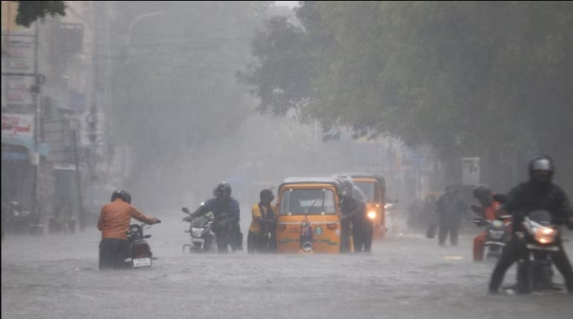

The IMD’s forecast for Sunday predicts increased rainfall activity, with light to moderate rain anticipated in multiple locations along the coast and isolated areas inland. Thunderstorms and lightning are also expected in some regions, making it crucial for residents to remain cautious.
Cyclonic Circulation Influences Weather Conditions
The weather pattern is being influenced by a cyclonic circulation in the lower tropospheric levels over the Southeast Bay of Bengal and adjacent Southwest Bay of Bengal. This system is contributing to the widespread rainfall and thunderstorm activity over Tamil Nadu, Puducherry, and Karaikal between January 12 and 14.
Extended Rainfall Forecast
- Coastal Andhra Pradesh & Yanam and Rayalaseema: Light to moderate rain with thunderstorms on January 13.
- Kerala & Mahe: Light to moderate rain with thunderstorms on January 13 and 14.
- Northeast India: Isolated thunderstorms and rainfall over Arunachal Pradesh, Assam, and Meghalaya on January 13 and 14.
Additionally, isolated heavy rainfall is predicted for Tamil Nadu, Puducherry, and Karaikal on January 12, making it the most rain-intensive day in this period.
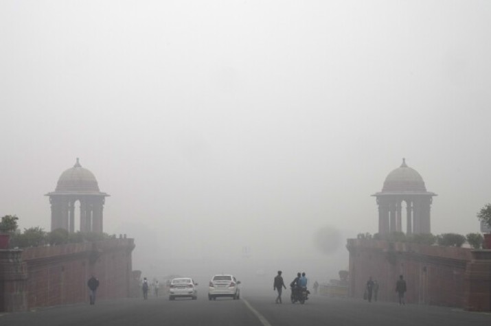
Fog and Cold Wave Conditions in North India
Meanwhile, dense fog and a cold wave continue to disrupt life in northern India. On Saturday morning, prominent landmarks like the Taj Mahal in Agra were shrouded in fog, while cities such as New Delhi, Kanpur, and Gwalior experienced reduced visibility.
The IMD recorded Delhi’s minimum temperature at 11°C, with dense fog limiting visibility to as low as 50 meters in Safdarjung during the early hours. Although flights at Indira Gandhi International Airport operated normally, several trains were delayed due to poor visibility.
Temperature and Fog Updates:
- The maximum and minimum temperatures in Delhi are expected to hover around 15°C and 8°C, respectively.
- Cold wave to severe cold wave conditions were observed in parts of Himachal Pradesh, with frost reported in isolated locations in Uttarakhand.
- Punjab, Haryana, and Uttar Pradesh also faced dense to very dense fog in some areas.
The lowest temperature in the plains was recorded at Karauli, Rajasthan, at 3.3°C on Friday.
Precautionary Measures
The IMD has urged residents of affected areas to take precautions, such as avoiding outdoor activities during thunderstorms and securing loose objects in homes. Commuters are advised to exercise caution due to slippery roads and reduced visibility in fog-hit regions. Farmers in rain-affected areas have been advised to secure crops and avoid irrigation during heavy rain spells.
As Tamil Nadu and other parts of the country brace for varied weather conditions, staying informed through local weather updates is essential to ensure safety and preparedness.
Also Read:-
40 People Affected as Ceiling Slab Collapses at Kannauj Railway Station
Ram Mandir Anniversary: Celebrating Tradition and Spirituality on January 11, 2025